
“If you can’t measure it, you can’t manage it”, those are the words declared by María Fernanda Espinosa Garcés, President of the United Nations General Assembly at the COP 24 in Katowice (Poland), summarizing how essential satellites are for coping climate emergencies.
A vast network of satellites links all the continents to each other by providing undiscussable services to society. Everything began when the first-ever artificial satellite, the Sputnik 1 was launched by the Soviet Union into space in 1957. Then, their usage had a remarkable impact on everyday life. Just thinking about the navigator used to move from one place to another one. They have made travelling more comfortable without having to lose orientation (and calm) on the maps. But there is another paramount role covered by satellites. Indeed, by means of this technology, society collects a huge amount of data regarding the climate system, 24 hours a day, seven days a week, without which scientists and decision-makers would not know how to cope with the climate emergency that humankind has been experiencing during the last decades.
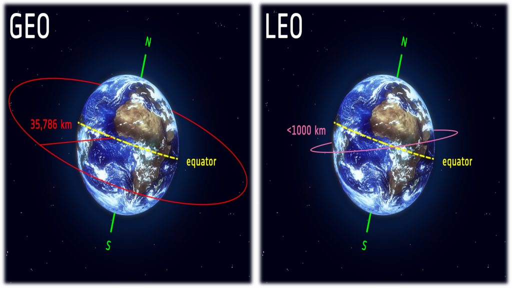
Basically, the satellites are divided into two categories: geostationary (GEO) and polar-orbiting (LEO) type. The first one has a geostationary orbit at high altitudes, around 36,000 km, at the same rotation speed as the Earth, in order to remain above the same spot. In this way, satellites can continually monitor a particular zone uninterrupted, except for the polar regions due to the Earth’s curvature. The polar-orbiting satellites are located at low altitudes, between 400 and 1400 meters from the Earth’s surface. circling the globe once every 100 minutes. In this last case, it is possible to obtain images and measurements with a high spatial resolution but the continuous observation of a particular geographical place is not possible. The synergic usage of both types of satellites allows them to complete each other combining the worldwide coverage of the first one with the high resolution of the last one.
1959 saw the first weather satellite, called Vanguard II, thought to monitor the density of the atmosphere and the cloud covering. Since that moment, a lot of “climate satellites” have been populating the earth orbit, up to an updated number of 162 to date. These kinds of satellites are able to detect the global environment, also catching the most hidden and remote places or events not observable by human eyes. Depending on its final purpose, the satellite is equipped with a series of instruments that measure a wide range of parameters that are useful for analysing the current and/or future situation. For instance, temperature, wind speed and direction, water vapour and so on, are detected to provide weather forecasting regarding atmospheric phenomena, while ocean currents, sea level height are used to detect maritime ones. By using high-resolution satellite images, harvested during these decades of monitoring, it is also possible to check the trend about lands and forests taken away because of human or desertification as well.
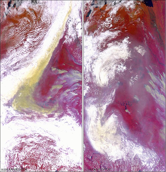
Thanks to this technology, the major impacts of climate change can be tracked, such as the effect on the radiation balance of burning fossil fuels or the hole in the ozone layer. Indeed, satellites are ideal for detecting the level of the concentration of greenhouse gases in the atmosphere, such as aerosols, water vapour, carbon monoxide, carbon dioxide and methane. An example is Ibuki, a Japanese satellite launched in 2009, which is the world’s first one specifically designed for observing greenhouse gases. It is a polar-orbiting satellite that can detect 56,000 points worldwide, providing the most overall view of the concentration of these gases so far. The following picture shows the smoke of wildfires in Russia on two occasions captured by Ibuki
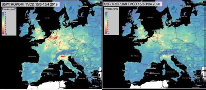
The rapidity of the information provided by satellites was shown immediately after the actions of the various governments to cope with the spread of the coronavirus. Indeed, it has been possible to note how the stop of vehicle traffic has decreased the nitrogen dioxide levels overall the world (As shown in the picture below).
Another example happened in 2017 when the world map changed forever thanks to the breakaway of a huge iceberg from the Antarctica landmass. This event is a clear demonstration of the fast decline of the ice sheet volume and consequently the rising of the sea level. Compared to the 1980s, the ice sheet is disappearing six times faster.
In conclusion, nevertheless the high cost of these technologies, it is undiscussable how they allow mankind to better understand what happened, is happening and will happen around the world, in order to cope altogether, in the overall of the countries, the climate emergency that is affecting life. A description of the characteristics of a part of the satellites dedicated to this role is offered by Nasa at the following website:
Source:
● https://ourworld.unu.edu/en/how-things-work-environmental-satellites
● https://climate.nasa.gov/nasa_science/missions/?page=0&per_page=40&order=title+asc&search=
● https://www.carbonbrief.org/interactive-satellites-used-monitor-climate-change
● https://www.geospatialworld.net/blogs/satellites-for-monitoring-climate-change/#:~:text=Copernicus%20Sentinel%2D5P%2C%20launched%20by,monitoring%20satellite%20in%20the%20world.&text=In%20January%202009%2C%20Japan%20launched,Gases%20Observing%20Satellite%20(GOSAT).